WORLD HEADQUARTERS 23201 MILL CREEK DRIVE, 3RD FLOOR LAGUNA HILLS, CA 92653 USA | PHONE: 866 951-2777
Google +Google +Google +LinkedinTwitterFacebook-
 Professional Land’s company owned headquarters
 Where is Southern California’s next major land boom?
 Learn about major residential developments!
 Learn about major master planned communities!
 Discover major shopping centers and malls!
 Find out about substantial retail and commercial growth!
 Discover large job creating industrial parks!
 Why are major companies relocating here?
 Discover a massive Logistics Airport with many global billion dollar companies!Call Us: (866) 951-2777
 Why is this Logistics Airport poised to become the largest cargo airport in the USA?
Mobile Menu =
Home
Free Land Buying Course
Inland Empire Profile
Victor Valley Profile
Barstow & Surrounding Communities
Kramer Junction Profile
Newberry Springs Profile
Antelope Valley Profile
Lancaster & Palmdale Profile
Rosamond Profile
Mojave Profile
California City Profile
Corporate Overview
Message From The Founders
Business References
Financing
Testimonials
Real Estate Career Opportunities
Blog
Contact
Learn to Use your IRA-Retirement Account to Acquire Prime Land
Free Land Buying Seminar
Free Land Banking Webinar
Newsletter Sign-Up
Land Banking Success
Dynamic Growth Areas
Land for Sale
About
Disclaimers and Legal
This Website contains CONFIDENTIAL TRADE SECRET INFORMATION owned by Professional Land Corporation and/or its affiliated companies. This information is protected by applicable state law and may be protected by the Federal Economic Espionage Act OF 1996 (18 U.S. C. Sec. 1832), which provides for imprisonment of up to ten years and a fine of $250,000 for individuals and a fine of up to $5,000,000 for organizations for stealing, receiving, transmitting, modifying, publishing, reproducing, possessing and/or duplicating any information contained herein unless you have obtained the prior written consent of Professional Land Corporation.
Copyright 2002-2026© Professional Land Corporation™ All Rights Reserved. The reproduction, duplication, distribution, publication, modification, copying or transmission of text and images from this Site is STRICTLY PROHIBITED unless you have obtained the prior written consent of Professional Land Corporation.
No warranties or representations are made whatsoever as to the investment merit or profit potential, the current and future market value, the current and future zoning, the resale potential, and/or the potential for future use or development of all or any portion of any land parcel. As a condition of purchasing any property, prospective buyers are required to rely solely upon their own independent analysis, investigation and due diligence before entering into an agreement to purchase a property. Furthermore, prospective buyers shall not rely on the information provided by this Website, the Seller and/or Seller's Agent in purchasing any property. Professional Land Corporation is the exclusive agent that represents only the Seller, and is affiliated with the Seller through common ownership. Past performance is not a guarantee of future results. The information contained in this Website is believed to come from reliable sources, but is not guaranteed.
Any property offered for sale in this Website is subject to prior sale, price change or withdrawal from the market without notice.
No warranties or representations are made as to the accuracy of the Google Translate Program.
Antelope Valley Profile
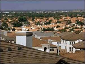
The Antelope Valley’s Population is Projected to be One Million by 2020
According to Wikipedia, the Antelope Valley is located in northern Los Angeles County, and the southeast portion of Kern County. The principal communities are Lancaster, Palmdale, Rosamond, Mojave, California City, and Edwards Air Force Base.
The Antelope Valley is home to over 475,000 people, and the population is expected to reach 1,000,000 by the year 2020. Major retail has followed the population influx, centered on Palmdale’s Antelope Valley Mall. The Antelope Valley is home to Lockheed Martin, Boeing, Northrop Grumman, and BAE Systems, among other aerospace-related companies. Notable projects assembled and/or designed there include the Space Shuttle orbiters, B-1 Lancer bomber, B-2 Spirit bomber, F-117 Nighthawk fighter, F-35 Joint Strike Fighter, and the Lockheed L-1011 Tristar, a passenger jet aircraft. This region also houses the newly dedicated Mojave Air & Space Port.-
NASA X-59 “Quiet” Supersonic Jet – First Flight Overview (2025)

According to Fox News dated October 29, 2025, the experimental X-59 Quesst, developed by Lockheed Martin Skunk Works with NASA, completed its first test flight in October 2025 at
Read More >> -
Palmdale Development & Growth Initiatives – 2025

According to the Antelope Valley Press dated October 8, 2025, major land developments are coming to Palmdale.
Commercial & Industrial Development
Palmdale is moving forward with a 56-acre lifestyle center at
Read More >> -
Antelope Valley Transit Authority Awarded $4.8 Million From Transit Intercity Rail Capital Program

According to the Antelope Valley Times, August 16, 2022, the Antelope Valley Transit Authority was awarded $4.8 million from the Transit Intercity Rail Capital Program (TIRCP), a state transportation grant
Read More >> -
Antelope Valley Named as a 2022 ‘Great American Defense Community’

As mentioned in the Antelope Valley Times, March 25, 2022, The Association of Defense Communities (ADC) announced that the Antelope Valley has been selected as one of five Great American Defense
Read More >> -
Metrolink Awarded $13.6M For Antelope Valley Line Railroad, Highway Safety Improvements

As stated in an article in the Antelope Valley Times, February 26, 2021, Metrolink announced it was awarded up to $13.6 million of Federal Highway Administration Section 130 Program
Read More >> -
AVEK Awarded Over $1.23 Million in Grants for Proposed Antelope Valley Projects

According to the Antelope Valley Times, June 30, 2020, Antelope Valley-East Kern Water Agency (AVEK) received notice from the California Department of Water Resources that AVEK was awarded $1,231,208
Read More >> -
Antelope Valley Transit Line to Receive $107 Million in Funding

As mentioned in the Antelope Valley Times, April 23, 2020, California Secretary of Transportation David Kim announced $107 million in Transit and Intercity Rail Capital (TIRCP) grants that will
Read More >> -
175 People Hired by Northrop Grumman in the Antelope Valley

According to the Antelope Valley Times, April 8, 2020, as a result of a $1 million grant provided in early 2020, 175 people were interviewed and hired by Northrop
Read More >>
This Website contains CONFIDENTIAL TRADE SECRET INFORMATION owned by Professional Land Corporation and/or its affiliated companies. This information is protected by applicable state law and may be protected by the Federal Economic Espionage Act OF 1996 (18 U.S. C. Sec. 1832), which provides for imprisonment of up to ten years and a fine of $250,000 for individuals and a fine of up to $5,000,000 for organizations for stealing, receiving, transmitting, modifying, publishing, reproducing, possessing and/or duplicating any information contained herein unless you have obtained the prior written consent of Professional Land Corporation.
Copyright 2002-2026© Professional Land Corporation™ All Rights Reserved. The reproduction, duplication, distribution, publication, modification, copying or transmission of text and images from this Site is STRICTLY PROHIBITED unless you have obtained the prior written consent of Professional Land Corporation.
No warranties or representations are made whatsoever as to the investment merit or profit potential, the current and future market value, the current and future zoning, the resale potential, and/or the potential for future use or development of all or any portion of any land parcel. As a condition of purchasing any property, prospective buyers are required to rely solely upon their own independent analysis, investigation and due diligence before entering into an agreement to purchase a property. Furthermore, prospective buyers shall not rely on the information provided by this Website, the Seller and/or Seller's Agent in purchasing any property. Professional Land Corporation is the exclusive agent that represents only the Seller, and is affiliated with the Seller through common ownership. Past performance is not a guarantee of future results. The information contained in this Website is believed to come from reliable sources, but is not guaranteed.
Any property offered for sale in this Website is subject to prior sale, price change or withdrawal from the market without notice.
No warranties or representations are made as to the accuracy of the Google Translate Program.
Translate »